
Mapping an area of land under jurisdiction has always been a priority of empires. Al Mamun, the Abbassid caliph took special interest in mapping the world so to know what fraction of it was under his own control.
He financed projects for mapping but soon it was realized that accurate distances cannot be measured because of the curvature of the earth.
Muslim scientists initially adopted the Greek method of measuring the curvature. This was done by measuring the angle of the sun when it was at Zenith and comparing it to the angle measured at a fixed distance due north. Although this technique furnished the radius and consequently the diameter of the earth but because of the crude measurements, this radius had an error of 4%.
It wasn’t till Abu Rehan Al Biruni arrived that a more accurate value for the diameter of earth was found with an error of less then 1%. Biruni described this method in his book the Masudi cannon (Qanoon al Masoodi). The beauty and the accuracy of this method lies in its simplicity.
Abu Rehan Al Biruni required first to find a point that was high enough to see a clear horizon (with no obstacles in the way). For this he chose a hill near the sea side. The purpose of the hill was not only just to furnish a clear line of sight to the horizon, but also to increase the declination angle to the horizon from a point on top of the hill to a measurable value.
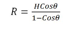
From the diagram above it is clear how knowing the height of the hill can give the radius of the earth, provided the declination angle theta is measured accurately. An astrolabe was used for measuring the angle.
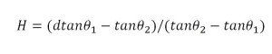
The only other unknown in the above equation was the height of the hill. Al Biruni measured that again using simple trigonometric equation.

He measured the elevation angle of the hill from two points on the foot of the hill. The distance between the two points had already been measured. Using this simple process and the equation below, the height of the hill could be easily estimated.

The BBC commissioned a documentary covering the remarkable achievements of Muslim scientist. The program was presented by Jim Al Khalili. This program can be accessed from the BBC directly from this link.
Or it can also be viewed from the following YouTube link.


